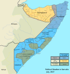
File:Somalia map states regions districts.png

預覽大小:582 × 600 像素。 其他解析度:233 × 240 像素 | 466 × 480 像素 | 952 × 981 像素。
原始檔案 (952 × 981 像素,檔案大小:262 KB,MIME 類型:image/png)
檔案歷史
點選日期/時間以檢視該時間的檔案版本。
| 日期/時間 | 縮圖 | 尺寸 | 使用者 | 備註 | |
|---|---|---|---|---|---|
| 目前 | 2023年9月30日 (六) 15:56 |  | 952 × 981(262 KB) | Seemsrathytaway | https://www.thehindu.com/news/international/pro-somalia-militia-takes-key-army-base-in-breakaway-region/article67238670.ece |
| 2020年6月20日 (六) 17:51 |  | 952 × 981(263 KB) | Chipmunkdavis | Rv to stable version | |
| 2020年6月20日 (六) 14:46 |  | 952 × 981(265 KB) | Meelpringthusss | See discussion at https://commons.wikimedia.org/wiki/File_talk:Somalia_map_states_regions_districts.png#There_is_nuance_with_regards_to_control | |
| 2020年6月19日 (五) 12:03 |  | 952 × 981(263 KB) | Chipmunkdavis | Reverted to version as of 16:32, 15 May 2017 (UTC) Map shows control, not claims. Otherwise a lot of changes would be needed. | |
| 2020年6月17日 (三) 15:07 |  | 952 × 981(265 KB) | Meelpringthusss | added disputed area per http://www.puntlandobserver.com/puntlands-boundary-issues-what-will-abdiweli-gass-call-for-unity-really-mean/ | |
| 2017年5月15日 (一) 16:32 |  | 952 × 981(263 KB) | Kzl55 | As of April 2017 | |
| 2017年4月18日 (二) 17:24 |  | 852 × 900(265 KB) | Kzl55 | An updated map. By Nicolay Sidorov. | |
| 2014年11月16日 (日) 22:32 |  | 3,000 × 3,169(1.64 MB) | AcidSnow | Updated territory inhabited by ethnic Somalis and fixed key. | |
| 2014年11月15日 (六) 17:54 |  | 3,000 × 3,169(1.71 MB) | AcidSnow | As of October 14, 2014. | |
| 2014年10月13日 (一) 02:33 |  | 3,000 × 3,169(1.7 MB) | AcidSnow | Updated territorial control and fixed the boundaries of the regions of Somalia. |
檔案用途
下列3個頁面有用到此檔案:
全域檔案使用狀況
以下其他 wiki 使用了這個檔案:
- af.wikipedia.org 的使用狀況
- ar.wikipedia.org 的使用狀況
- azb.wikipedia.org 的使用狀況
- ca.wikipedia.org 的使用狀況
- ckb.wikipedia.org 的使用狀況
- cs.wikipedia.org 的使用狀況
- cy.wikipedia.org 的使用狀況
- de.wikipedia.org 的使用狀況
- el.wikipedia.org 的使用狀況
- en.wikipedia.org 的使用狀況
- Transitional Federal Government of Somalia
- Al-Shabaab (militant group)
- Battle of Bargal (2007)
- File talk:Somalia map states regions districts.png
- Wikipedia:Graphics Lab/Map workshop/Archive/May 2009
- United Nations Security Council Resolution 1587
- 2012 timeline of the Somali Civil War
- Wikipedia:Graphics Lab/Map workshop/Archive/May 2012
- User:Mir Almaat 1 S1/Islamic Emirate of Somalia
- 2013 in Somalia
- Wikipedia:Graphics Lab/Photography workshop/Archive/Jul 2013
- Wikipedia:Graphics Lab/Map workshop/Archive/Sep 2013
- List of conflicts in Somalia
- Wikipedia:Graphics Lab/Map workshop/Archive/Apr 2014
- Battle of Leego (2015)
- Battle of El Adde
- en.wikinews.org 的使用狀況
- en.wikivoyage.org 的使用狀況
- eo.wikipedia.org 的使用狀況
- es.wikipedia.org 的使用狀況
- et.wikipedia.org 的使用狀況
檢視此檔案的更多全域使用狀況。


