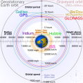
File:Comparison satellite navigation orbits.svg

此 SVG 檔案的 PNG 預覽的大小:512 × 512 像素。 其他解析度:240 × 240 像素 | 480 × 480 像素 | 768 × 768 像素 | 1,024 × 1,024 像素 | 2,048 × 2,048 像素。
原始檔案 (SVG 檔案,表面大小:512 × 512 像素,檔案大小:42 KB)
檔案歷史
點選日期/時間以檢視該時間的檔案版本。
| 日期/時間 | 縮圖 | 尺寸 | 使用者 | 備註 | |
|---|---|---|---|---|---|
| 目前 | 2021年2月27日 (六) 04:48 |  | 512 × 512(42 KB) | Glrx | Fix SVG errors: systemLanguage attr on desc element; misuse of switch element; use SVG 2.0 rules; delete DOCTYPE |
| 2020年9月24日 (四) 14:49 |  | 512 × 512(43 KB) | Drhyme | File uploaded using svgtranslate tool (https://svgtranslate.toolforge.org/). Added translation for ko. | |
| 2020年9月24日 (四) 14:44 |  | 512 × 512(40 KB) | Drhyme | File uploaded using svgtranslate tool (https://svgtranslate.toolforge.org/). Added translation for ko. | |
| 2020年9月24日 (四) 14:35 |  | 512 × 512(36 KB) | Drhyme | File uploaded using svgtranslate tool (https://svgtranslate.toolforge.org/). Added translation for ko. | |
| 2020年9月22日 (二) 19:41 |  | 512 × 512(29 KB) | Cmglee | Reverted to version as of 18:10, 19 August 2020 (UTC) as text is now misaligned and descriptions are removed | |
| 2020年9月21日 (一) 11:31 |  | 512 × 512(23 KB) | Leonel Sohns | Valid SVG. | |
| 2020年8月19日 (三) 18:10 |  | 512 × 512(29 KB) | Ravenpuff | Specify supplementary systemLanguage="en" in switch tags as per Commons guidance | |
| 2020年8月19日 (三) 01:11 |  | 512 × 512(25 KB) | Cmglee | Fix broken hover effects and redundant text. | |
| 2020年6月30日 (二) 17:55 |  | 512 × 512(33 KB) | Galaktos | change http: to https: (except in doctype or xmlns) and wikipedia.org to en.wikipedia.org | |
| 2020年6月23日 (二) 19:43 |  | 512 × 512(33 KB) | Cmglee | Try again |
檔案用途
下列5個頁面有用到此檔案:
全域檔案使用狀況
以下其他 wiki 使用了這個檔案:
- af.wikipedia.org 的使用狀況
- ar.wikipedia.org 的使用狀況
- be.wikipedia.org 的使用狀況
- bg.wikipedia.org 的使用狀況
- bn.wikipedia.org 的使用狀況
- ca.wikipedia.org 的使用狀況
- de.wikipedia.org 的使用狀況
- en.wikipedia.org 的使用狀況
- Global Positioning System
- Galileo (satellite navigation)
- Geostationary orbit
- Communications satellite
- GLONASS
- Van Allen radiation belt
- Orbital speed
- Talk:Geostationary orbit
- Geocentric orbit
- Space law
- Specific orbital energy
- Graveyard orbit
- Satellite navigation
- Wikipedia:WikiProject Physics
- Portal:Outer space
- Medium Earth orbit
- Wikipedia:Featured pictures/Space/Understanding
- Wikipedia:WikiProject Astronomy/Recognized content
- List of orbits
- Template:Earth orbits
- Wikipedia:WikiProject Physics/Recognized content
- Wikipedia:WikiProject Spaceflight/Recognized content
- Wikipedia:WikiProject Spaceflight/Downlink/RCWatchlist
- Template:Comparison satellite navigation orbits
- User:Cmglee/2011
- User:Cmglee/drawing
- Wikipedia:WikiProject Astronomy/Recognized astronomy content
- Portal:Outer space/Selected picture
- Wikipedia:Reference desk/Archives/Science/2013 November 14
- User:Cmglee/svg
- Wikipedia:Reference desk/Archives/Science/2016 June 6
- Wikipedia:Featured pictures thumbs/61
- User talk:Nergaal
- Wikipedia:Featured picture candidates/March-2018
- Wikipedia:Featured picture candidates/Earth orbits
- Wikipedia:Reference desk/Archives/Science/2018 April 12
- Wikipedia:Wikipedia Signpost/2018-04-26/Featured content
- Wikipedia:Wikipedia Signpost/Single/2018-04-26
檢視此檔案的更多全域使用狀況。


