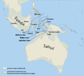
File:Map of Sunda and Sahul.png

本预览的尺寸:661 × 599像素。 其他分辨率:265 × 240像素 | 530 × 480像素 | 847 × 768像素 | 1,111 × 1,007像素。
原始文件 (1,111 × 1,007像素,文件大小:208 KB,MIME类型:image/png)
文件历史
点击某个日期/时间查看对应时刻的文件。
| 日期/时间 | 缩略图 | 大小 | 用户 | 备注 | |
|---|---|---|---|---|---|
| 当前 | 2017年3月5日 (日) 08:07 |  | 1,111 × 1,007(208 KB) | Chumwa | corr |
| 2009年7月25日 (六) 06:46 |  | 1,111 × 1,007(269 KB) | Chumwa | Inseln -> Islands | |
| 2009年7月25日 (六) 06:13 |  | 1,111 × 1,007(268 KB) | Chumwa | {{Information |Description= {{ de }}Karte von Sunda und Sahul sowie der Wallace-Linie, der Lydekker-Linie und der Weber-Linie. * Als Sahul wird die zusammenhängende Landmasse bezeichnet, die während der letzten Eiszeit aus Australien, der nordöstlich d |
文件用途
全域文件用途
以下其他wiki使用此文件:
- ar.wikipedia.org上的用途
- ast.wikipedia.org上的用途
- az.wikipedia.org上的用途
- be.wikipedia.org上的用途
- bg.wikipedia.org上的用途
- bn.wikipedia.org上的用途
- ca.wikipedia.org上的用途
- cs.wikipedia.org上的用途
- de.wikipedia.org上的用途
- en.wikipedia.org上的用途
- Dingo
- New Guinea singing dog
- List of lost lands
- Sahul Shelf
- Red-naped trogon
- Australia (continent)
- Models of migration to the Philippines
- Denisovan
- Canis lupus dingo
- User:Cruickshanks/Sandbox
- User:Obsidian Soul/sandbox
- Wikipedia:Reference desk/Archives/Science/2011 May 15
- List of butterflies of the Philippines
- Wikipedia:Categories for discussion/Log/2015 June 26
- eo.wikipedia.org上的用途
- es.wikipedia.org上的用途
- fa.wikipedia.org上的用途
- fi.wikipedia.org上的用途
查看此文件的更多全域用途。


