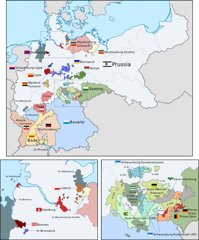
File:German Empire states map.svg

此SVG文件的PNG预览的大小:496 × 600像素。 其他分辨率:198 × 240像素 | 397 × 480像素 | 635 × 768像素 | 847 × 1,024像素 | 1,694 × 2,048像素 | 1,042 × 1,260像素。
原始文件 (SVG文件,尺寸为1,042 × 1,260像素,文件大小:2.42 MB)
文件历史
点击某个日期/时间查看对应时刻的文件。
| 日期/时间 | 缩略图 | 大小 | 用户 | 备注 | |
|---|---|---|---|---|---|
| 当前 | 2024年6月1日 (六) 21:45 |  | 1,042 × 1,260(2.42 MB) | Alphathon | Improved a few borders and removed some redundant (duplicated) paths |
| 2024年6月1日 (六) 19:58 |  | 1,042 × 1,260(2.35 MB) | Alphathon | Corrected Austria-Hungary–Russia border | |
| 2024年4月26日 (五) 14:04 |  | 1,042 × 1,260(2.34 MB) | Heiliges | File uploaded using svgtranslate tool (https://svgtranslate.toolforge.org/). Added translation for ko. | |
| 2024年4月26日 (五) 13:55 |  | 1,042 × 1,260(2.34 MB) | Heiliges | File uploaded using svgtranslate tool (https://svgtranslate.toolforge.org/). Added translation for ko. | |
| 2024年4月26日 (五) 13:47 |  | 1,042 × 1,260(2.32 MB) | Heiliges | File uploaded using svgtranslate tool (https://svgtranslate.toolforge.org/). Added translation for ko. | |
| 2019年2月24日 (日) 02:43 |  | 1,042 × 1,260(2.31 MB) | Alphathon | Corrected Brunswick territory accidentally given to Anhalt | |
| 2015年11月4日 (三) 14:55 |  | 1,042 × 1,260(2.39 MB) | Alphathon | Slight optimisation | |
| 2015年11月4日 (三) 01:33 |  | 1,042 × 1,260(2.39 MB) | Alphathon | Another minor tweak | |
| 2015年11月4日 (三) 01:31 |  | 1,042 × 1,260(2.39 MB) | Alphathon | Tweaked colours | |
| 2015年11月3日 (二) 22:25 |  | 1,042 × 1,260(2.39 MB) | Alphathon | Corrected typo |
文件用途
以下3个页面使用本文件:
全域文件用途
以下其他wiki使用此文件:
- ar.wikipedia.org上的用途
- ast.wikipedia.org上的用途
- az.wikipedia.org上的用途
- ca.wikipedia.org上的用途
- en.wikipedia.org上的用途
- es.wikipedia.org上的用途
- fi.wikipedia.org上的用途
- he.wikipedia.org上的用途
- hu.wikipedia.org上的用途
- it.wikipedia.org上的用途
- ko.wikipedia.org上的用途
- nl.wikipedia.org上的用途
- pt.wikipedia.org上的用途
- sr.wikipedia.org上的用途
- th.wikipedia.org上的用途


