跳转到内容

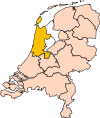
File:Limburg position.svg

页面内容不支持其他语言。
这个文件来自维基共享资源
维基百科,自由的百科全书

原始文件 (SVG文件,尺寸为200 × 236像素,文件大小:157 KB)


摘要

描述 Location of the province of Limburg in the Netherlands.
日期
来源 Own work, based on freely available GIS data
作者 User:Mtcv
授权
(二次使用本文件)
Data: attribution required; my work: PD
其他版本 I attempted to make an svg version of Image:Limburg-Position.png (with less simplified boundaries)

Clickable version

South HollandNorth HollandFrieslandGroningenDrentheFlevolandOverijsselGelderlandUtrechtLimburgNorth BrabantZeeland

许可协议

© 本文件的著作权人,Centraal Bureau voor de Statistiek,允许任何人在适当地表明著作权人的姓名的前提下,以任何目的使用本文件。传播,演绎作品,商业用途及所有其他用途被允许。

VRT Wikimedia

本作品是自由作品,任何人都可以以任何目的使用。如果您想要使用该内容,只要您遵守本页面上提到的许可协议要求,您不需要请求授权。

维基媒体基金会已收到电子邮件,确认版权持有者同意根据本页面提到的条款发表本作品。该信件已被志愿者回应团队(VRT)成员审阅并存储于我们的授权档案中。受信任的志愿者可前往 工单编号#2007041210008226查阅相关信件。

如果您对存档信件有疑问,请使用VRT通告板 工单链接: https://ticket.wikimedia.org/otrs/index.pl?Action=AgentTicketZoom&TicketNumber=2007041210008226
查找来自同一工单的其他文件: SDC query (SPARQL)

This image is (in part or entirely) based on geographical data from Statistics Netherlands (Centraal Bureau voor de Statistiek). Digital geometry files in ESRI format can be downloaded from their website [1].

In particular, boundary data of statistical districts is based on either the Wijk- en buurtkaart 2005, or the Wijk- en buurtkaart 2003 ("CBS/TOPgrenzen"). Data on localities (bevolkingskernen) are from the publication Bevolkingskernen in Nederland 2001.

Conditions of use (in Dutch):

  • Bij visualisering van gegevens met behulp van het digitale bestand Wijk- en buurtkaart 2005 dient te worden vermeld:
Bron: © 2006, Centraal Bureau voor de Statistiek / Topografische Dienst Kadaster
  • Bij visualisering van gegevens met behulp van het digitale bestand CBS/TOPgrenzen dient te worden vermeld:
Grenzen ondergrond: © 2003, Centraal Bureau voor de Statistiek/Topografische Dienst Kadaster
  • Bij visualisering van gegevens met behulp van het digitale bestand "Bevolkingskernen 2001" dient te worden vermeld:
Bron: © 2005, Centraal Bureau voor de Statistiek

Unless otherwise specified, data on waterways and lakes are from the public domain Digital Chart of the World.

注解
InfoField
该图片含有注解:在维基媒体共享资源上查看注解

说明

添加一行文字以描述该文件所表现的内容

此文件中描述的项目

描绘内容

版权状态 简体中文(已转写)

版权所有 简体中文(已转写)

许可协议:​仅需姓名标示授权条款 中文(已转写)
适用部分:​地理数据 中文(已转写)
版权所有者 简体中文(已转写):​荷兰中央统计局 Chinese (Singapore)(已转写)

维基媒体VRTS工单号码 简体中文(已转写)

适用部分:​地理数据 中文(已转写)

文件历史

点击某个日期/时间查看对应时刻的文件。

日期/时间缩⁠略⁠图大小用户备注
当前2019年3月2日 (六) 17:192019年3月2日 (六) 17:19版本的缩略图200 × 236(157 KB)Thaytsupdate
2006年10月3日 (二) 00:502006年10月3日 (二) 00:50版本的缩略图200 × 236(158 KB)Mtcv{{Information| |Description=Location of the province of Noord-Holland (North Holland) in the Netherlands. |Source=Own work, based on freely available GIS data |Date=2006-10-03 |Author=User:Mtcv |Permission=Data: attribution required; my work: PD |othe

全域文件用途

元数据