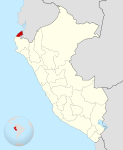
File:Location of Tumbes region.png
Location_of_Tumbes_region.png (238 × 347 像素,檔案大小:30 KB,MIME 類型:image/png)
檔案歷史
點選日期/時間以檢視該時間的檔案版本。
| 日期/時間 | 縮圖 | 尺寸 | 用戶 | 備註 | |
|---|---|---|---|---|---|
| 目前 | 2005年2月2日 (三) 04:56 |  | 238 × 347(30 KB) | StarbucksFreak | Location of the Tumbes region in Peru |
檔案用途
下列頁面有用到此檔案:
全域檔案使用狀況
以下其他 wiki 使用了這個檔案:
- ba.wikipedia.org 的使用狀況
- be.wikipedia.org 的使用狀況
- de.wikipedia.org 的使用狀況
- en.wikipedia.org 的使用狀況
- Contralmirante Villar province
- Tumbes province
- Zarumilla province
- Aguas Verdes
- Zorritos
- Zarumilla
- Zarumilla River
- Tumbes River
- Acapulco, Peru
- Cañaveral, Peru
- Aguas Verdes District
- Tumbes National Reserve
- Tumbes District
- Corrales District
- La Cruz District, Tumbes
- Pampas de Hospital District
- San Jacinto District
- San Juan de la Virgen District
- Matapalo District
- Papayal District
- Zarumilla District
- Casitas District
- Zorritos District
- Canoas de Punta Sal District
- Template:Tumbes-geo-stub
- Punta Sal
- fi.wikipedia.org 的使用狀況
- fo.wikipedia.org 的使用狀況
- id.wikipedia.org 的使用狀況
- ja.wikipedia.org 的使用狀況
- ka.wikipedia.org 的使用狀況
- ko.wikipedia.org 的使用狀況
- ms.wikipedia.org 的使用狀況
- no.wikipedia.org 的使用狀況
- pt.wikipedia.org 的使用狀況
- ru.wikipedia.org 的使用狀況
- war.wikipedia.org 的使用狀況
- www.wikidata.org 的使用狀況


